Saturday, December 10, 2011

Ch. 18 Hawaii

Florida like Hawaii are known for beautiful beaches, tourism, beautiful weather and surfing. Florida’s history of surfing actually started in the early 1930’s with a few Virginia Beach lifeguards, namely John Smith and Babe Braithwait, renting concession stands at the beaches and demonstrating the sport with Hawaiian surfboards [1]. 


Cocoa Beach, home to six-time World Champion Kelley Slater and Ron Jons, the world's most famous surf shop which receives 2 million visitors a year. Cocoa Beach is also home to the East Coast Surfing Hall of Fame.

Florida unveils their bronze tribute to surfing's Champ10n of champions, Mr. Kelly Slater


Ch. 16 The North Pacific Coast

The North Pacific Coast has the greatest average annual precipitation on the continent. The precipitation average of 600 cm is more than twice of any other area (except Hawaii) in the United States or Canada. Like The North Pacific Coast, Florida also receives a lot of precipitation in large part because afternoon thunderstorms are common in most of the state from late spring until early autumn. 


The biggest difference between the North Pacific Coast and Florida is in it's topography. While the North Pacific Coast offers a land of mountains and breath taking views, Florida is very flat and lacks many mountains and is around sea level.
 

Ch. 15 California

This chapter discusses California. California is much different than Florida in many ways including the weather, the topography and the hazards that it's residents face. Florida is know for Hurricanes and California is famous for it's earthquakes. California does not experience any hurricanes due to the surface temperature of the Pacific ocean being very cold during the whole year. California residents face the daily fears of the possibility of an earthquake. California is home to a fault line called the San Andreas fault which is responsible for the majority of the earthquakes including small ones that are common to very large ones that are not as common but when they strike can cause major damage throughout.


[1] The San Andreas Fault has had some notable earthquakes in historic times:
  • 1857 Fort Tejon earthquake: About 217 miles (349 km) were ruptured in central and southern California. Though it is known as the Fort Tejon earthquake, the epicenter is thought to have been located far to the north, just south of Parkfield. Only two deaths were reported. The magnitude was about 7.9.
  • 1906 San Francisco earthquake: About 267 miles (430 km) were ruptured in Northern California. The epicenter was near San Francisco. At least 3000 people died in the earthquake and subsequent fires. This time the magnitude was estimated to be 7.8.
  • 1989 Loma Prieta earthquake: About 25 miles (40 km) were ruptured (although the rupture did not reach the surface) near Santa Cruz, California, causing 63 deaths and moderate damage in certain vulnerable locations in the San Francisco Bay Area. Moment magnitude this time was about 6.9. The earthquake also postponed game 3 of the 1989 World Series at Candlestick Park. This quake occurred on October 17, 1989, at approximately 5:04 P.M. PDT.
  • 2004 Parkfield earthquake: On September 28, 2004, at 10:15 A.M. PDT, a magnitude 6.0 earthquake struck California on the San Andreas Fault.

Earthquake Damage to San Francisco 1906

Earthquake Damage to San Francisco 1906
 
Earthquakes are such a big concern for California that one of the most visible impacts is the skyline of California's big cities like Los Angeles. Due to Earthquake laws there is a limit to how tall the buildings can be built. Thankfully for California, breakthroughs in structural design and materials have now paved way to larger construction. Today many Californians still have belief in the "The Big One". The big one refers to an Earthquake of larger magnitude of a 7.0. Researchers believe that due to the extended time without major seismic activity from the San Andreas that tremendous stress is forming and that one day that stress will give and we will have the big one.

Source 1

Ch. 14 The Southwest border area

One of the major topics of discussion in this chapter is immigration and how it has had an impact on the southwest border. This is also true for Florida. Political upheaval in Cuba created new waves of Cuban immigrants to the U.S. In 1959, after the Cuban revolution led by Fidel Castro, a large Cuban exodus began as the new government allied itself with the Soviet Union and began to introduce communism. The tables below show how the major destination of choice after fleeing Cuba was Florida.


Before the 1980s, all refugees from Cuba were welcomed into the United States as political refugees. This changed in the 1990s so that only Cubans who reach U.S. soil are granted refuge under the "wet feet, dry feet policy". While representing a tightening of U.S. immigration policy, the wet foot, dry foot policy still affords Cubans a privileged position relative to other immigrants to the U.S. This privileged position is the source of a certain friction between Cuban Americans and other Latin citizens and residents in the United States, adding to the tension caused by the divergent foreign policy interests pursued by conservative Cuban Americans. Cuban immigration also continues with an allotted number of Cubans (20,000 per year) provided legal U.S. visas [1].


Source 1

Ch. 13 The Empty Interior

The Empty interiors dry region is dependent on projects that will divert water from different rivers in order to get proper irrigation for it's crops. Without these projects it would not be possible to grow crops in the region and the agriculture that dominates the interior would not exist. Florida shares some of the Empty Interior water problems. Although Florida receives abundant rainfall they depend on drawing water from wells faster than they can recharge it naturally. One of the main problems is caused by Florida's flat topography and being unable to construct large reservoirs hence the need to drill and create wells. The inability of the rainfall to recharge the water table due to development in Florida results in the land loosing support from the water table which then causes large sinkholes. The Farmers in Florida consume about half of the water supply for agriculture of sugar cane (can require lots of water) and citrus.


Damage to a house in Florida that was cause by sinkhole

 To prevent the abundant waste of water Florida's water management has enacted year round water conservation and limitations to use. There's also major campaigning to try to reduce the over use of water in an effort to try and restore some of the water table.

The Organization has also implemented new incentives and has offered a award for water conservation implementation. Projects that use technology to implement water conservation are under consideration for funding through this program. Award recipients are reimbursed for up to 50 percent or up to $50,000, whichever is less, of the actual total project. Types of projects that have received funding in previous years include automatic line flushing devices for hydrants, indoor plumbing retrofits, large area irrigation controls, and soil moisture and rain sensor technology for irrigation systems [1].


Source 1

Ch. 12 The Great Plains and Prairies

The Great Plains and Prairies share similarities with Florida as in that they share Tornado alley. As seen below the Great Plains and Prairies and Florida share a more common threat of Tornadoes. No other region in the United States shares this similarity.


The clash of the contrasting air masses that are characteristic of the Great Plains create these powerful hazards that are capable of enormous amounts of damage.

Ch. 11 The Agricultural Core

The agricultural core is characterized by adequate rainfall with little annual variability, coupled with ample growing seasons, which makes the region a good place to grow corn and other crops. Although, Florida is not part of the Agriculture core, Florida is still productive in agriculture and shares some of the benefits of a longer growing season. Florida's is famous for being a large citrus producer mainly oranges and grapefruit. In 2008 Florida had 47,500 commercial farms, utilizing 9.25 million acres to continue to produce a variety of food products [1].


As shown above, Florida has multiple products besides oranges and grapefruit including Livestock, field crops, a forest industry, seafood, etc. Florida farmers produces crops that are grown in few parts of the United Sates and Canada. 


 Source 1

Ch. 10 The Southern Coastlands

The Southern Coastlands is a subtropical and humid place that appeals to many travelers and retirees that seek beautiful beaches and the Gulf of Mexico's warm waters. Florida makes up the majority of the Southern Coastlands.
Fig 10.1 The Southern Coastlands.

Winter freeze is a threat many Florida farmers face when growing crops in the Southern Coastlands. Fooled by the mild winters that Florida is known for they sometimes underestimate the occasional mid-winter frost that cause major damage to crops and have considerable financial loss.


Icicles cling to oranges  

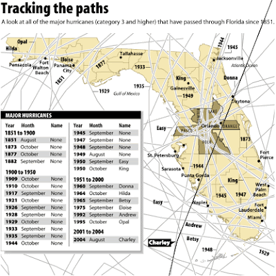
The biggest threat Florida faces yearly are Hurricanes and the large amount of damage they can cause.  Of all the recorded hurricanes to hit the U.S. since 1851, 36 percent have made landfall in Florida. A look at the paths of the major hurricanes (category 3 and higher) that have passed through the state. The most affected counties are in the shaded area [1].


Fig 10.3 Hurricane Hazard Zones.


Source 1